Better Solutions
Re-purpose the 710
Beyond the 710 -
Moving Forward
A Better Alternative to the Tunnel that relieves traffic, connects communities, promotes smart growth, and helps people get to their jobs, schools, shopping, and recreation.
Connecting Pasadena Project The CPP aims to develop a draft Master Plan for the 35 acre strip of land flanking the 710 stub. CPP Status (PDF)
City of Pasadena
Press Release
City Working Group determines the SR-710 Tunnel option is not for Pasadena,3/2015
Freeway & Expressway Revolts
Freeways do not need to be finished. The high number of freeways planned in the 1950s were later reevaluated.
End of the Road for the 710?
Cities find that tearing down freeways can lead to revitalization of the area. Los Angeles Business Journal, Richard Risemberg, 8/9/2010
Highway Expansion Relieves Congestion - It's a Myth!
Study demonstrates that highway construction is not the answer to providing congestion relief
Arterial
Improvements
Multi-Mode, Low Build
Many cities have made recommendations to transportation officials that would cost less, have shorter time-lines, and keep jobs local
Port Alternatives
CargoWay
Flexible (Compressed Natural Gas/Electric) trams that travel on both roads and elevated guideways
Research on CargoWay
Summary of the CargoWay system
MegaRail Roam Letter to GCCG
MegaRail notifies Gateway Cities Council of Governments that engineering study conducted by URS for the Ports of LA/LB was flawed and didn't fairly evaluate the alternatives to freight trucks
Electrification of Rail
Caltrans/Cal Poly, Pomona report, Electrification of the Freight Train Network from the Ports of Los Angeles and Long Beach to the Inland Empire, 5/2008
Freight Shuttle
Electric powered transporters over elevated guideways
GRID
A sorting and zero-emission container supply chain
Updated 8/1/2015
Metro Has Failed To Adequately
Consider Green Alternatives
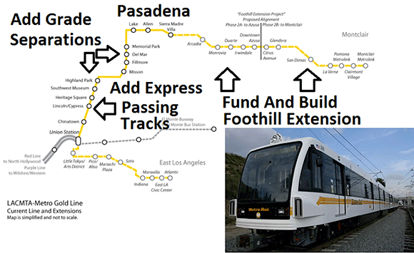
- Metro Gold Line Improvements (Grade Separations, Express Train Passing Tracks, Extension To Claremont and Ontario Airport).
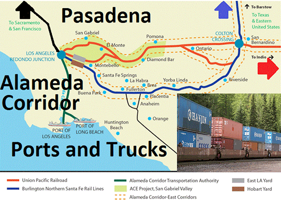
- Rail Improvements For Goods (Use 710 Funds To Complete Alameda Corridor And Move Freight By Train).
- Other Low-Build Alternatives
Metro has not considered
Gold Line Improvements
Metro has not considered
Rail Improvements
Any time a governmental agency plans for an action that might effect the ecosystem, the National Environmental Policy Act (NEPA) requires that there be a Scoping Process.
Scoping Process
A process that allows for early identification of potentially significant environmental issues. This process begins with an introduction to the environmental review agencies and the public, the purpose of which is to initiate coordination and involvement activities that will span the life of the project. Agencies with specialized knowledge of these areas may be asked to participate as cooperating agencies, while other agencies are required by law to participate in project development.
This is quoted from Section 4F of the NEPA Glossary
The following is a letter from Mark Vallianatos*. His Scoping submission sent to Caltrans on 4/11/11 was one of many letters that recommended thoughtful design when addressing transportation issues.
*Mark Vallianatos, Policy Director
Urban & Environmental Policy Institute
Occidental College
Scoping comments on SR-710 ‘gap closure' project
April 11, 2011
The west San Gabriel Valley, Northeast Los Angeles, Pasadena, Glendale, and other cities and communities along the Arroyo Seco corridor are among the most diverse in California. The area has a rich cultural history and important natural and ecological sites. The opening of the Metro Gold Line has provided a new sense of connection between these communities and opportunities for transit-oriented development and more sustainable land use in the region.
The region is divided and surrounded by numerous freeways: the 710, 10, 210, 110, 134, 5, 2, 101, 60, and 605. These freeways bring deadly particulate pollution and noise. They promote car-centric land use and mobility, which have contributed to epidemics of obesity and diet-related illness. The construction of these freeways disrupted communities, especially low income communities of color.
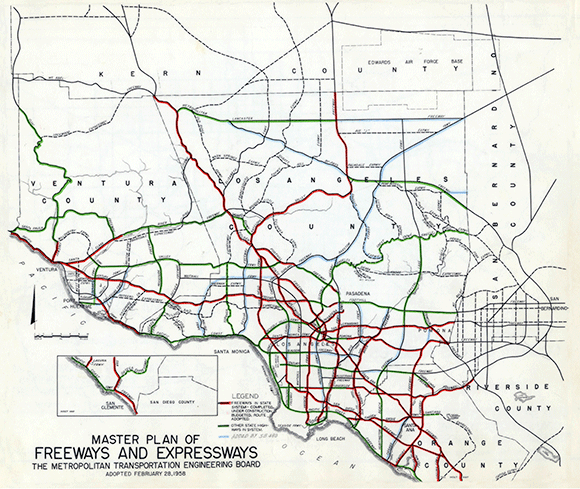
Metro and Caltrans have a choice to make in investing billions of dollars to address mobility and congestion in this area. They can look to the past, to early-mid 20th century freeway plans, by extending SR-710 to the 210 via a surface or tunnel route. This backwards-looking approach (see 1958 map of the massive and thankfully never fully implemented freeway and expressway system), would further pollute and divide communities. These plans are from an era when the car was supposed to solve all mobility challenges. They are outdated relics from a period before scientists understood the health risks of particulate pollution and the threat of climate change; and before planners and health officials fully understood that a freeway and car-based transportation system would lead to sprawl, sedentary lifestyles, and inefficient land use patterns.
Or the agencies can adopt 21st century transportation solutions to move people and products in a way that improves the environment and surrounding communities. In these scoping comments, we suggest four priority transportation improvements for the project area under review. We also urge the agencies to conduct Health Impact Assessments of the freeway option and alternatives to accompany environmental review.
- Remove the SR-710 freeway between the 10 freeway and Valley Blvd by transforming it into a surface street and/ or a linear park.
- Expand transit to reduce car traffic and pollution and spur transit-oriented development
- Create complete, living and green streets that promote safe walking and cycling and create vibrant public spaces.
- Reduce freight truck traffic and pollution by expanding on dock rail at the Ports of Los Angeles and Long Beach.
- Conduct a health impact assessment of all alternatives.
1. Remove the SR-710 freeway between the 10 freeway and Valley Blvd by transforming it into a surface street and/ or a linear park.
Smart metropolitan regions are beginning to undue some of the damage done by the urban freeway frenzy of the 1950s-1970s. Cities such as San Francisco, Soeul, Korea, and Portland have achieved gains in quality of life, economic development, and mobility by transforming sections of freeways into boulevards, open space, and parks.
- Removing Freeways - Restoring Cities
- Highways to Boulevards
- Seoul tears down an urban highway
- 7 Urban Freeways To Tear Down Today
- And What Tomorrow Might Look Like If We Do - Case Studies in Urban Freeway Removal (PDF that must be read on-line)
- San Francisco: Removal of the Embarcadero Freeway
- MBA: Highway Removal
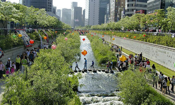
Below: Cheonggye stream in Seoul, formerly covered by a freeway.
(Image by flickr user elzed)
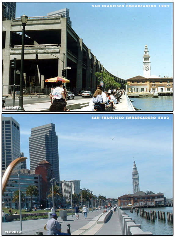
Below: Embarcadero before and after freeway removal.
(Flickr user vision63)
The approximately mile-long stub of Sdate for removal and transformation.R-710 that extends north of the 10 freeway to Valley Blvd is a promising candi
- Caltrans and Metro should decommission this section of SR-710 and transform it into a non-grade-separated, complete, living and green street as discussed above and/or into a park and open space.
- The agencies should conduct a community planning exercise involving residents, municipalities, and California State University Los Angeles to determine how to best transform the removed section freeway. To limit exposure to freeway pollution, the lower 1500-2000 feet of the new boulevard/ park could be a buffer zone/ ecological remediation zone with more active uses in the northern two-thirds of the site.
- The agencies should ensure that this closure does not worsen pollution in adjacent communities. This can be accomplished by increasing transit, reducing truck freight trips, and conducting a health impact assessment.
2. Expand transit to reduce car traffic and pollution and spur transit-oriented development
Rapidly expanding the transit network in the area under review is the best way to reduce passenger car traffic and improve denser, walkable land uses. There are significant gaps in transit in the area under review, especially north-south between the northern and southern sections of the San Gabriel Valley and between Northeast Los Angeles and Glendale and the San Fernando Valley. Glendale is in fact the most populous city in Los Angeles County without a light rail connection.
- Extend metrorail northwest from one of the Pasadena Gold Line stations through Eagle Rock, Glendale and Burbank to the Burbank airport then south to connect to the terminus of the Red Line in North Hollywood. This would create a valuable northern loop between the Gold and Red lines that would expand links between the San Gabriel Valley and the San Fernando Valley and better connect the population and job centers of Glendale and Burbank to the region's light rail system.
- Accelerate extending the Gold Line eastwards as planned in the Foothill extension and Eastside extension.
- Create metrorail, metroliner or dedicated busway north-south corridors between the two arms of the Goldline. This could follow Atlantic and Huntington to connect the East L.A. civic center station to the planned Gold Line foothill extension station in Arcadia. As the foothill extension and east side extensions of the Gold Line continues, Metro should consider further North-South Spurs every 3-5 miles similar to the East Valley north south corridors being studied in the San Fernando Valley.
North-South Corridor Study (PDF-Note: 9.1 MB)
These types of dedicated rail or bus routes would expand the transit grid and improve north south alternatives to car transportation.
3. Create complete, living, and green streets that promote safe walking and cycling and create vibrant public spaces.
Streets let people move between places. Streets are also important public space in themselves. Throughout much of the 20th century, traffic engineers designed wide streets with wide lanes and high speed limits in an effort to maximize the flow of cars per hour at peak traffic times. These design standards created streets that are dangerous to walk or bike on and near. Streets designed as ‘sewers for cars' also harm the places they are supposed to connect by making it unpleasant to be outside due to the speed and noise and sterile visual environment of streets. Fortunately, some cities are reinventing streets for the 21st century. These streets are complete in that they dedicate space for all modes of transportation with wide sidewalks, bike lanes (including protected or separated bike lanes), bus only lanes, flex lanes, modern streetcars, etc. They are living and vibrant because they calm traffic, create more and safer pedestrian crossings, more public plazas and seating, and welcome walkers and bikers who bring life to sidewalks and streets and customers to local business. They are green because they are designed with more shade trees, less blacktop, and with landscaping and permeable surfaces to capture and filter rainwater. For example, the My Figueroa project examining street improvements for South Figueroa St. in Los Angeles is demonstrating best practices for 21st century streets.
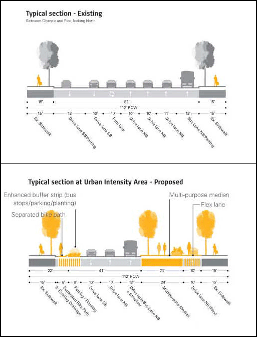
The Los Angeles County Department of Public Health is funding development of a model streets manual that incorporates similar goals of living, safe, and complete streets. Model Streets Manual on Its Way — Move Over Old Traffic Handbook. The project area for the SR-710 ‘gap closure' project has a number of major streets that are too wide, unpleasant, and unsafe. These could greatly benefit from being made more complete, living, and green.
- As part of an alternative to freeway extension, Metro and Caltrans should launch planning efforts like the My Figueroa project for twelve streets and implement cutting edge improvements on these streets of the type that will be contained in the Los Angeles County funded street manual.
- Huntington drive
- Valley Blvd
- Mission Blvd
- Main st/ Las Tunas Dr
- Fremont ave
- Atlantic Blvd
- Rosemead Blvd
- San Gabriel Blvd
- San Fernando Rd
- Eagle Rock Blvd
- Colorado Blvd
- Figueroa St
- Metro should work with municipalities and the County to ensure that a network of bike lanes, protected bike lanes, bike paths and bike infrastructure is rapidly implemented in the project area, with a goal of increasing cycling's mode share of trips to at least 10 percent. Bike lane projects promote clean, healthy transportation and also create more jobs per dollar invested than road projects.
4. Reduce freight truck traffic and pollution by expanding on dock rail at the Ports of Los Angeles and Long Beach.
One of the perceived needs for extension of SR-710 is high levels of truck traffic on the existing route and expectations of continuing increases in freight imports and truck traffic. The solution to this challenge isn't expanding or extending freeways. It is reducing truck traffic by shifting freight movement to less polluting modes of goods movement and reassessing the desirability of endless growth in the logistics industry. A recent report by the U.S. Government Accountability Office found that externalities from truck freight transport were approximately six times more per unit carried than for freight rail. "According to our synthesis of EPA's latest national emissions inventory data (2002), freight trucks produced over six times more fine particulate matter and over four times more nitrogen oxide on a ton-mile basis than freight locomotives, and over 10 and six times more of each type of emission, respectively, on a ton-mile basis than inland waterway vessels. And, according to our analysis of EPA data on greenhouse gases, trucks emitted the highest levels of greenhouse gas (CO2 equivalents) among the freight modes—about eight times more per unit of freight than freight rail, and thirteen times more than waterways freight."
GAO. SURFACE FREIGHT TRANSPORTATION: A Comparison of the Costs of Road, Rail, and Waterways Freight Shipments That Are Not Passed on to Consumers. January, 2011. http://www.gao.gov/new.items/d11134.pdf
- Caltrans and Metro should work with the Ports of Los Angeles and Long Beach to expand capacity for on-dock rail so that imports can be loaded directly onto freight trains, reducing the need for trucks to transport containers to warehouses, inland rail yards, and transloading facilities.
- Caltrans and Metro should work with the ports to set a target and plan for reduced truck traffic on SR-710.
- The agencies should work with the ports, railroad companies and regulators to accelerate adoption of electrified and cleaner locomotive technologies and to ensure that increased train facilities and trips do not increase negative health impacts.
5. Conduct a health impact assessment of all alternatives.
Freeways are sources of dangerous air pollution, especially from diesel exhaust.
- Children living near freeways face higher risks of asthma, worse asthma, and reduced lung growth. McConnell, R, T Islam, K Shankardass, M Jerrett, F Lurmann, J Gauderman, E Avol, N Kuenzli, L Yao, J Peters and K Berhane. 2010.
- Childhood incident asthma and traffic-related air pollution at home and school. Environmental Health Perspectives; McConnell, R., et al. (2006). "Traffic, Susceptibility, and Childhood Asthma." Environ Health Perspect 114(5): 766–772; Gauderman, W. J., E. Avol, et al. (2005).
- "Childhood asthma and exposure to traffic and nitrogen dioxide."
Epidemiology 16(6): 737-43; Gauderman, W.J. et al. (2007) - "Effect of exposure to traffic on lung development from 10 to 18 years of age: a cohort study."
Lancet 369(9561):571-7.) - Exposure to traffic-related air pollution is also associated with higher rates of heart disease and cancer in adults.
Kramer et al. (2010). - Traffic-related air pollution and incident type 2 diabetes: Results from the SALIA cohort study. Environmental Health Perspectives; Beelen, et al.
- "Long-Term Exposure to Traffic-Related Air Pollution and Lung Cancer Risk." Epidemiology 19 (5): 702-710 (2008); Kan et al,
- "Traffic exposure and lung function in adults: the Atherosclerosis Risk in Communities study."
Thorax 2007 62: 873-879 (2007).
In addition to EIR/EIS, Caltrans and Metro should conduct a health impact assessment of all project alternatives, including the surface freeway, tunnel and other alternatives.
The agencies should learn from the ongoing Health Impact Assessment of the SR-710 expansion project being performed by Human Impact Partners and ICF International with input from Los Angeles County Department of Public Health.
- Health Impact Assessment Blog - Update from human impact partners
- Why a Comprehensive Health Analysis in the I-710 EIR/EIS? (PDF that must be read online.)
- I-710 Project: Need for a Comprehensive Health Analysis (PDF that must be read online.)